


The description of GPS Photo Viewer use GoogleMap
Please watch the teach video to know how to use it. (Have description if watch video from PC or Notebook.)
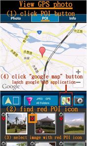
When you go to travel and take a picture, I suggest you to enable camera's GPS. After you enable camera's GPS function, then the GPS latitude and longitude will record in the captured photo. This application is help you to check the photo have a GPS info or not. And help to launch the Google map.
If your photo (jpeg file) doesn't have a GPS info, this application also can help you to edit it. So you can know where to take this picture. A few years later, you also know where this place is.Memories are important thing in our life.So remember enable GPS when take a picture!!!
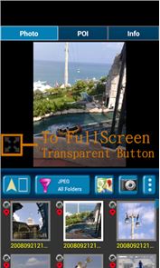
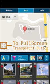
Function : 1. Fast check/edit photo's GPS information. 2. Fast check photo's camera information. 3. Navigate GPS-POI in google map. 4. Launch to "google map application" with photo's GPS location. 5. When launch this application, the final selected photo will be shown. So it is quickly to index the final selected photo. It is convenient! Purpose : 1. You can copy your GPS photos to your friends, and then they can go there if they are interest. 2. Want to know where to take the picture. (Take a GPS photo when park your car, you will find your car easily.) 3. Want to know the "focal length", "aperture", "ISO" value in the photo. V1.1.0:1. change MAP to google map V3. a) support traffic/weather/panoramio layer. b) support street view. c) support place search.
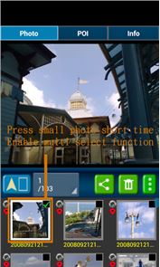
V1.1.1:1. Support edit photo's latitude/longitude. (Only JPEG file can edit latitude/longitude) (a-1) Press the small photo a long time to enable photo multi-select. (a-2) Select photos. (up to 20 photos) (a-3) Select option button, then tap "edit poi" button to enter edit-page.
Others : 1. It could be slow at first time loading image. After decoding finish, it will be fast. 2. Remember turn on GPS funtion when you take a picture. And the photo will contail GPS info. 3. Your phone need already install "google map application" and "google play service" before run this application. 4. Tap the small picture for some time, share/delete/rename/rotate function will enable. PS: In the Line/Facebook photo sharing, latitude and longitude info will be removed. If you want to share the latitude and longitude info, we recommend to use email/Gmail. [Q&A] : 1. How to capture a photo that contain a GPS tag? Ans: 1) Enable `Use wireless networks` and `Use GPS satellites` in `Location services` page. 2) Enable WIFI or 3G/4G network for fast locaton search. 3) Enable GPS function in the camera application.
【PS】 Please like us on Facebook. Give us the power of love. https://www.facebook.com/jkfantasy
How to play GPS Photo Viewer use GoogleMap on PC
Download and Install Nox App Player Android Emulator. Click here to download: Download(FREE)
Run Nox App Player Android Emulator and login Google Play Store
Open Google Play Store and search GPS Photo Viewer use GoogleMap Download
Install GPS Photo Viewer use GoogleMap and start it
Well done! Now you can play GPS Photo Viewer use GoogleMap on PC, just like GPS Photo Viewer use GoogleMap for PC version.